Canalblog
Editer l'article Suivre ce blog Administration + Créer mon blog
Publicité
My Algerian Post
Box shop
Archives
21 janvier 2014

Bechar : capitale du sud ouest algérien

Béchar est une ville du sahara non loin de la frontière du Maroc.

Source: Flickr


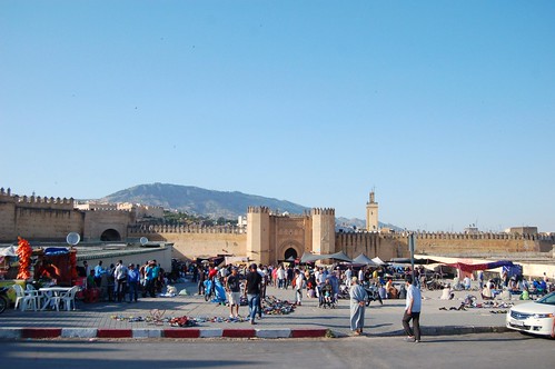
Capital du sud ouest algérien,: ville moderne ,bien structurée on y trouve des hôtels de grande qualité ,des restaurants et des auberges de jeunes .

Bechar est une des anciennes villes d'Algérie, chef lieu de wilaya ,elle se situe dans une zone stratégique du sud ouest algérien. C'est un carrefour des civilisations méditerranéennes et d'Afrique. La ville de est située à 950 km au sud ouest d'Alger la capitale , d'une superficie de plus de 5000 km² dont plus de 2000 hectares de terres agricoles . Elle est entourée d'une chaîne de montagne à savoir :


- Djebel Antar 1953m
- Djebel Grouz 1835m
- Djebel Béchar 1206 m.

BECHAR


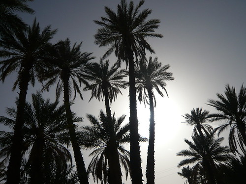
Le climat est chaud et sec en été et très froid en hiver , la pluviométrie ne dépassant pas les 100 m/m par an. La population est estimée à plus de 251657 habitants en 2005. Mis à part les conditions climatiques et le phénomène des distances , la ville de Bechar ne diffère guère d'une ville du nord du pays , elle dispose d'un aéroport national , d'une université ,d'une gare routière et gare ferroviaire d'un stade omnisports, d'une maison de la culture ,piscines et de plusieurs hôtels et auberges de jeunes de grande qualité . Cliquez ici pour voir quelques photos anciennes et récentes de Bechar.

Source: Flickr


La centrale électrique : (appelé communément par les gens CENTRA ) située à mi-chemin entre Bechar et Bechar Djedid ,tire son origine de l'emplacement de la centrale électrique des houillères qui produit de l'électricité (110V) pour Bechar , Bechar Djedid et Kénadsa. C'est grâce à elle que la population a vu de la lumière pour la première fois.

Source: Flickr

Bechar djedid: Situé au sud de la ville de Bechar à 7 km , appelé dans le temps Bidon deux, à l'origine était construit pour le personnel des houillères travaillant dans la mine de charbon.

A voir dans les environs :

Source: Flickr

ABADLA : ville connue par son oued dit "oued GUIR" , par sa plaine de 3000 hectares de terres fertiles. Elle est connue également par un folklore unique dans la région qui est le hobby .

Tout d'abord, cette ville porte le même nom que la fraction qui se nomme les Abadla et qui appartient à la tribu des Doui Menia. Ce nom a été donné par les Francais pendant la colonisation entre 1915 et 1930 car cette fraction nomadisait à cet endroit. Cette ville n'existait pas, et anciennement c'est à dire avant la colonisation Française dans la région cet endroit s'appelait "GUIR" car il se trouvait à proximité d'un fleuve du même nom "OUED GUIR".
A l'origine, les Abadla sont une fraction de la tribu des Doui Menia, mais pendant la colonisation, les Français ont décidé qu'elle devienne une tribu, je pense par souci administrative.


Avant qu'elle devienne une tribu, la fraction des Abadla se composait de trois sous-fractions :


* Les Oulad Ahmed qui détiennent le commandement chez les Abadla,
* Les Oulad Ammi Mbark
* Les Hadb

Lorsque les Abadla sont devenus une tribu, il y a eu trois fractions qui sont venues grossir le noyau des Abadla :

* Les Soualem
* Les Baggara
* Les Oulad Yaïch


Ces trois fractions sont des cousins des Abadla
: Les Abadla, les Soualem, les Baggara, et les Oulad Yaïch appartiennent tous à la fraction des Oulad Bouanane, et leur ancêtre commun est Ameur qui était fils de Naji Ben Bouanane Ben Menna. Principalement, les Oulad Bouanane nomadisaient entre l'Oued Guir (Aujourd'hui cet endroit s'appelle Abadla) et le Tafilalet (Région qui se trouve au Maroc). La population de cette ville se compose essentiellement de membres de la tribu des Doui Menia. En ce qui me concerne, je suis originaire de la sous-fraction des Oulad Ahmed qui se trouve chez les Abadla, ma famille détient le commandement depuis le 18 éme siécle jusqu'au jour d'aujourd'hui. Les Oulad Ahmed sont des chorfas, car ils descenderaient en ligne directe du Prophète (SAW).

Source: Flickr


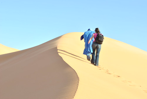
KERZAZ: Ville accueillante, siége de la Zaoui de Sidi ahmed Benmoussa , sa renommée a dépassé les frontières , situé à 120 km de Bebi-Abbes.Kerzaz se caractérise par une hospitalité légendaire ,région ou le silence plane dans les grandes espaces infinis , des dunes de sable dorées qui s'étendent à l'horizon infini.

Source: Flickr


BENI-ABBES:situé a 250 km de Bechar sur la route nationale n°6 sur l'axe Bechar-Adrar, deux hôtels dont le Grand Erg communément appelé dans le temps hôtel" Citroën" construit par la maison Citroën pour ses relais dans le sud ouest , actuellement hôtel Rym de renommé mondiale où s'est déroulé il y quelques années le film "Thé au Sahara" du réalisateur italien Berlusconi Bertolucci.

Source: Flickr

Beni Abbes à 260 kms de Béchar possède une palmeraie magnifique, un musée et des paysages superbes.


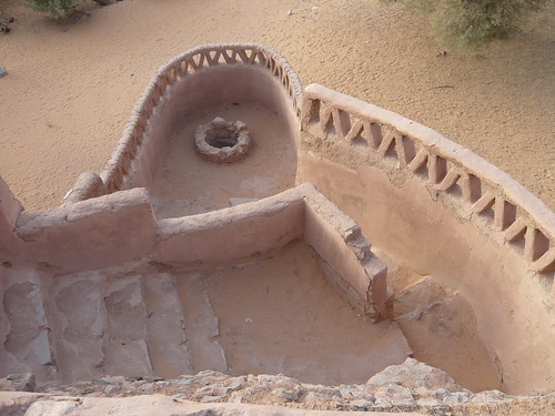
Le ksar Ghar-diba ,à quelques mètres de l'actuelle station d'essence NAFTAL implanté sur les bords de la falaise qui surplombe Béni-Abbes , était protégé de remparts formant un grand cercle entourant l'ensemble de la surface ,il subsiste encore des traces apparentes des murs de ce ksar qui est fondé par les Bni Hcien. A l'entrée de la grotte sous la falaise à 3 mètres du sol se dresse un tableau figuratif de signes intacts, qui atteste la présence d'une des tribus qui ont marqué cette région.

La légende de la naissance de la source de Beni-Abbes raconte que vers le 6éme siècle de l'hégire, Sidi Othmane venu d'Égypte campa avec son compagnon prés de la colline de Hmama durant trois jours ,il enfonça son bâton par terre et ordonna à son camarade de ne le relever qu'après sa mort.


Son compagnon exécuta le vœux de Sidi Othmane et retira le bâton de la terre et à cet instant l'eau jaillit et depuis l'AIN de Béni-Abbes coulait.
Situé à hauteur d'une des importantes dunes de sable du grand Erg Occidental , par son site naturel ,la densité de sa palmeraie en forme de scorpion , son eau d'une qualité supérieure ,Beni-Abbes est très séduisante .

Les deux Ksar que compte la ville dominent la rive droite de la vallée d'Oued Guir.
Avec l'ermitage du père de Foucault ,le musée , le vieux Ksar perdu au cœur de la palmeraie et et avec ses traditions Beni-Abbes présente un intérêt touristique certain .

Source: Flickr


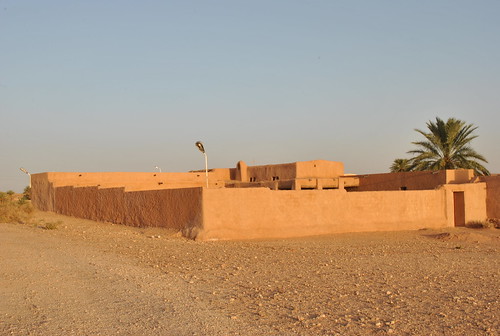
KSOURS DU NORD : Trois ksars Boukais, Mougheul et Lahmar situés au nord de la vile de Béchar se distinguent par un folklore commun qui est le Hidous .

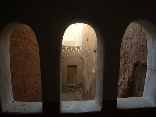
Le ksar de Boukais encore intact , une promenade dans ses sombres ruelles vous replonge dans le passé lointain, il se distingue par sa source à l'eau tiède en hivers et le mausolée de sid El Hadj saint patron du village où de nombreux malades viennent invoquer la miséricorde divine.

TABELBALA:connu par le mystère de ses tombes géantes de 7 à 8 m de long par son dialecte qui est difficile à comprendre . La tradition orale rapporte que lors de la prière du Sobh , le muezzin aurait aperçu des flammes à un endroit non loin de la mosquée , accompagné de quelques fidèles , il vint s'enquérir de l'origine du feu .Alors ils trouvèrent sept tombes encore fraîches et des traces de chameaux ...et depuis une coupole s'est érigée en l'honneur de ces sept hommes.

Comme pour toute la région du Sahara , l'histoire de cette localité est difficile à écrire la légende raconte que vers le 6 éme siècle de l'hegire , les habitants de Taghit étaient si nombreux (KOUM), de là viendrait l'appellation de Beni Goumi .A cet époque serait apparu un homme saint ,qui avait quitté sa ville à Baghdad et s'installa à Taghit pour prêcher le coran , ce saint s'appela Sidi Mohamed Bayazid ,après sa mort une Kouba(stèle) sera érigée entre Berrebi et Bakhti en son honneur et qui portait son nom jusqu'à nos jours.

Publicité
Commentaires
L
Une recette de Béchar : LA RATE FARCIE.<br /> <br /> <br /> <br /> Une rate de boeuf ou de veau.<br /> <br /> 200 g de viande hachée veau ou boeuf et 200 g de merguez<br /> <br /> ou bien 400 g de chair à saucisse.<br /> <br /> 150 g de mie de pain trempée.<br /> <br /> 1 jaune d'oeuf ail persil 2 piments hachés( selon les go�ts ).<br /> <br /> 1 cuillère à soupe de cumin.<br /> <br /> 5-6 cuillères d'huile.<br /> <br /> 1 verre d'eau.<br /> <br /> sel poivre.<br /> <br /> <br /> <br /> Préparation.<br /> <br /> <br /> <br /> Défaire les merguez et ajouter à la viande hachée + tous les ingrédients + l'oeuf battu sel poivre et bien mélanger le tout.<br /> <br /> Inciser la rate et bien la creuser sans ab�mer les bords,remplir cette poche avec la farce.<br /> <br /> Coudre l'ouverture(maman mettait une feuile de salade avant).<br /> <br /> Badigeonner la rate avec l'huile et mettre au four dans un plat avec un peu d'eau au fond.<br /> <br /> Cuire à four moyen pendant deux heures en arrosant la rate de temps en temps.<br /> <br /> Plat à manger chaud ou froid selon les go�ts ou même en tranches grillés.
Répondre
L
بشار : العاصمة الجزائرية في جنوب غرب<br /> <br /> <br /> <br /> بشار هي مدينة في الصحراء قرب الحدود مع المغرب .<br /> <br /> <br /> <br /> عاصمة جنوب غرب الجزائر : المدينة الحديثة، وهناك تنظيما جيدا للفنادق عالية الجودة والمطاعم و بيوت الشباب .<br /> <br /> بشار هي واحدة من أقدم المدن في الجزائر ، عاصمة ولاية ، وهي تقع في منطقة استراتيجية في جنوب غرب الجزائر . بل هو مفترق طرق الحضارات البحر الأبيض المتوسط ​​و أفريقيا. وتقع المدينة 950 كم من الجزائر العاصمة ، وتبلغ مساحتها أكثر من 5000 كم ² منها جنوب غرب أكثر من 2،000 دونم من الأراضي الزراعية . أنها محاطة بسلسلة جبال على النحو التالي :<br /> <br /> <br /> <br /> - جبل عنتر 1953m<br /> <br /> - جبل Grouz 1835m<br /> <br /> - جبل بشار 1206 م .<br /> <br /> <br /> <br /> مناخ حار وجاف في الصيف و بارد جدا في فصل الشتاء وهطول الأمطار لا تتجاوز 100 م / م سنويا. يقدر عدد السكان في أكثر من 251657 نسمة في عام 2005. وبصرف النظر عن الظروف المناخية وظاهرة بعد، بلدة بشار يكاد يختلف من مدينة في الشمال ، أن لديها مطار وطنية ، جامعة ، محطة للحافلات و محطة للسكك الحديدية من استاد رياضي ، بيت الثقافة ، وحمامات و العديد من الفنادق و بيوت الشباب جودة عالية . انقر هنا لرؤية بعض الصور القديمة والجديدة ل بشار.<br /> <br /> <br /> <br /> محطة الطاقة (تسمى عادة من قبل الشعب CENTRA ) الواقعة في منتصف الطريق بين بشار وبشار Djedid ، تنبع من موقع محطة طاقة الفحم التي تنتج الكهرباء ( 110V ) ل بشار ، بشار Djedid و Kenadsa . وبفضل لها أن الشعب رأى ضوء للمرة الأولى.<br /> <br /> <br /> <br /> بشار Djedid : تقع إلى الجنوب من مدينة بشار 7 كم ، ودعا الوقت يمكن اثنين ، وقد بنيت في الأصل لل موظفين العاملين في منجم للفحم الفحم .<br /> <br /> <br /> <br /> لمعرفة المجاورة:<br /> <br /> <br /> <br /> العبادلة : المعروف عن النهر الذي يطلق عليه " اكليل الوادي " التي كتبها في سهل 3،000 هكتار من الأراضي الخصبة المدينة . وكما هو معروف من قبل الفولكلور فريدة من نوعها في المنطقة والتي هي هواية.<br /> <br /> <br /> <br /> أولا، هذه المدينة له نفس الاسم كما يطلق على جزء من العبادلة و ينتمي إلى قبيلة Doui المنيا . أعطيت هذا الاسم من قبل الفرنسيين خلال فترة الاستعمار بين عامي 1915 و 1930 لأن هذا جزء nomadisait في هذا الموقع. هذه المدينة لم تكن موجودة، و أي سابقا قبل الاستعمار الفرنسي في المنطقة كان يسمى هذا المكان " إكليل " لأنه كان بالقرب من النهر الذي يحمل نفس الاسم " واد إكليل " .<br /> <br /> في الأصل ، و العبادلة هي جزء من قبيلة Doui المنيا ، ولكن خلال الاستعمار ، فقد قرر الفرنسيون أن يصبح قبيلة ، أعتقد أنه قلق الإدارية.<br /> <br /> <br /> <br /> قبل أن يصبح قبيلة ، و جزء من العبادلة يتألف من ثلاثة أجزاء فرعية هي:<br /> <br /> <br /> <br /> * و أولاد أحمد الذين هم في السلطة بين العبادلة ،<br /> <br /> * و أولاد عمي مبارك<br /> <br /> * الحدب<br /> <br /> <br /> <br /> عندما أصبحت قبيلة العبادلة ، كان هناك ثلاثة كسور التي تضخم العبادلة الأساسية :<br /> <br /> <br /> <br /> * و Soualem<br /> <br /> * و البقارة<br /> <br /> * و أولاد Yaïch<br /> <br /> <br /> <br /> هذه الكسور الثلاثة هم أبناء عمومة العبادلة : إن العبادلة على Soualem ، و البقارة ، و أولاد Yaïch ينتمون جميعا الى جزء من أولاد Bouanane ، و الجد المشترك بينهما هو كان عامر ناجي بن بن بن Bouanane منة . في المقام الأول ، أولاد Bouanane الحياة البدوية بين واد Guir ( اليوم يسمى هذا المكان العبادلة ) و تافيلالت (منطقة تقع في المغرب ) . يتكون سكان هذه المدينة معظمهم من أفراد قبيلة Doui المنيا . في حالتي، أنا من الكسر الفرعية أولاد أحمد الذي هو في العبادلة ، يحمل عائلتي الأمر من القرن ال 18 حتى اليوم. أولاد أحمد هي chorfas لأنهم descenderaient في خط مباشر من النبي ( ص) .<br /> <br /> <br /> <br /> Kerzaz : مدينة مريح ، مقعد سيدي أحمد زاوي بنموسى يتميز شهرته خارج حدود ، وتقع على بعد 120 كم من بيبى - Abbes.Kerzaz من قبل الضيافة الأسطوري، المنطقة أو الصمت في مساحة كبيرة لا حصر له شقة، الكثبان الرملية الذهبية التي تمتد إلى الأفق اللانهائي .<br /> <br /> <br /> <br /> بني ABBES : تقع على بعد 250 كيلومترا من الطريق السريع الوطنى بشار على رقم 6 على ادرار بشار المحور ، فندقين ، بما في ذلك عرق جراند يسمى عادة في الوقت فندق " سيتروين " التي بناها سيتروين المنزل ل تتابع له في جنوب غرب ، والآن الفندق الشهير العالم ريم التي وقعت قبل بضع سنوات فيلم " السماء الواقية " للمخرج الإيطالي بيرتولوتشي برلسكوني.<br /> <br /> <br /> <br /> بني عباس 260 كيلومترا بشار لديه بستان النخيل الجميلة، و متحف و المناظر الطبيعية الخلابة.<br /> <br /> <br /> <br /> القصر غار - ديبا ، على بعد أمتار قليلة من محطة نفطال البنزين الحالي الموجود على حافة الهاوية تطل بني عباس ، و التي تحميها جدران تشكيل دائرة كبيرة حول كامل السطح ، لا تزال هناك آثار واضحة على جدران هذا القصر الذي أسسه أخطار الحريق Hcien . عند مدخل الكهف تحت الهاوية إلى 3 أمتار فوق سطح الأرض تقف جدول علامات سليمة التصويرية ، مما يدل على وجود واحدة من القبائل التي ميزت هذه المنطقة.<br /> <br /> <br /> <br /> وقال أسطورة ولادة مصدر بني عباس التي ل ه القرن 6 ، وجاء سيدي عثمان إلى مصر نزلوا مع رفيقه قرب تل Hmama لمدة ثلاثة أيام ، وقال انه التوجه عصاه على أرض الواقع و أمر من شأنه تلبية رفيقه بعد وفاته.<br /> <br /> <br /> <br /> قام رفيقه من رغبات سيدي عثمان وسحبت العصا من الأرض في هذا الوقت و يتدفق الماء من العين و تدفقت بني عباس .<br /> <br /> تقع في الكثبان الرملية كبيرة من عرق العظمى الغربية ، من خلال موقعها الطبيعي ، وكثافة العقرب على شكل النخيل ، و المياه ذات جودة أعلى ، بني عباس جذابة جدا.<br /> <br /> <br /> <br /> كل من قصر في المدينة التي تهيمن على الضفة اليمنى من الوادي واد Guir .<br /> <br /> مع المحبسة الأب فوكو ، المتحف، فقد قصر القديمة في قلب بستان نخيل و تقاليدها و بني عباس لديه بعض الاهتمام السياحي .<br /> <br /> <br /> <br /> KSOURS NORTH : ثلاثة ksars Boukais ، Mougheul لحمر و تقع إلى الشمال من بشار الخسيس تمييزها من قبل الفولكلور المشتركة التي هي Hidous .<br /> <br /> <br /> <br /> القصر من Boukais تزال على حالها ، المشي في الأزقة المظلمة له بعودتكم في الماضي البعيد ، وتتميز بها مصدره لتسخين المياه في فصل الشتاء و ضريح الحاج سيد شفيع القرية حيث يأتي العديد من المرضى إلى الاعتماد الرحمة الإلهية .<br /> <br /> <br /> <br /> Tabelbala : يعرف سر له شهري تموز وآب م هجة طويلة العملاقة والتي من الصعب أن نفهم القبور. ويتعلق التقاليد الشفوية أنه أثناء صلاة الفجر ، و المؤذن قد لاحظوا النار في مكان غير بعيد عن المسجد ، يرافقه عدد قليل من الأتباع، وقال انه جاء للاستفسار عن أصل النار ، لذلك وجدوا سبع مقابر حتى الآن شيد الطازجة و آثار الإبل ... و من قبة تكريما لل رجال السبعة.<br /> <br /> <br /> <br /> أما بالنسبة ل كامل منطقة الصحراء ، و تاريخ هذا المكان من الصعب كتابة أسطورة، إلى القرن 6 ه عشر ، كان الناس تاغيت كثيرة ( كوم ) ، سيأتي هناك اسم أن بني Goumi . في هذا الوقت ظهرت رجل المقدسة ، الذين غادروا المدينة و انتقل إلى بغداد تاغيت للتبشير القرآن ، وكان يسمى المقدسة سيدي محمد بايزيد ، وبعد وفاته في القبة ( الشاهدة ) ستقام بين بربي و بهاكتى تكريما له و تحمل اسمه حتى اليوم.
Répondre
L
Bechar : Algerian capital of southwest<br /> <br /> <br /> <br /> Bechar is a city of the Sahara near the border with Morocco .<br /> <br /> <br /> <br /> Capital of southern Algeria west : modern city, there are well structured for high quality hotels , restaurants and youth hostels .<br /> <br /> Bechar is one of the oldest cities in Algeria , capital of wilaya , it is located in a strategic area of southwestern Algeria. It is a crossroads of Mediterranean civilizations and Africa. The city is located 950 km southwest of the capital Algiers , an area of ​​more than 5000 km ² of which more than 2,000 acres of farmland. It is surrounded by a mountain range as follows:<br /> <br /> <br /> <br /> - Djebel Antar 1953m<br /> <br /> - Jebel Grouz 1835m<br /> <br /> - Djebel Bechar 1206 m.<br /> <br /> <br /> <br /> The climate is hot and dry in summer and very cold in winter , rainfall not exceeding 100 m / m per year. The population is estimated at more than 251,657 inhabitants in 2005. Apart from the climatic conditions and the phenomenon of distance , the town of Bechar hardly differs from a city in the north , it has a national airport, a university, a bus station and railway station of a sports stadium , a house of culture, pools and several hotels and youth hostels high quality . Click here to see some old and new pictures of Bechar .<br /> <br /> <br /> <br /> Power plant ( commonly called by the people CENTRA ) located halfway between Bechar and Bechar Djedid , originates from the location of the power station coal that produces electricity (110V) for Bechar, Bechar Djedid and Kenadsa . It is thanks to her that the people saw the light for the first time .<br /> <br /> <br /> <br /> Bechar Djedid : Located south of the town of Bechar 7 km , called time Can two , was originally built for the staff working in the coal mine coal .<br /> <br /> <br /> <br /> To see nearby :<br /> <br /> <br /> <br /> Abadla : known for its river called " wadi Wreath " by its plain 3,000 hectares of fertile land city. It is also known by a unique folklore in the region which is the hobby.<br /> <br /> <br /> <br /> Firstly, this city has the same name as the fraction is called the Abadla and belongs to the tribe Doui Menia . This name was given by the French during the colonial period between 1915 and 1930 because this fraction nomadisait at this location. This city did not exist, and formerly ie before the French colonization in the area this place was called " Wreath " because it was near a river of the same name " OUED Wreath " .<br /> <br /> Originally, the Abadla are a fraction of the tribe of Doui Menia , but during the colonization , the French have decided that it becomes a tribe , I think by administrative concern .<br /> <br /> <br /> <br /> Before it becomes a tribe , the fraction of Abadla consisted of three sub- fractions:<br /> <br /> <br /> <br /> * The Oulad Ahmed who are in authority among Abadla ,<br /> <br /> * The Oulad Ammi Mbark<br /> <br /> * HADB<br /> <br /> <br /> <br /> When Abadla became a tribe , there were three fractions which have swelled the core Abadla :<br /> <br /> <br /> <br /> * The Soualem<br /> <br /> * The Baggara<br /> <br /> * The Oulad Yaïch<br /> <br /> <br /> <br /> These three fractions are cousins ​​Abadla : The Abadla the Soualem , the Baggara , and Oulad Yaïch all belong to the fraction of Oulad Bouanane , and their common ancestor is Ameur was Naji son Ben Bouanane Ben Menna . Primarily, Oulad Bouanane nomadic life between Oued Guir (Today this place is called Abadla ) and Tafilalet (Region located in Morocco). The population of this city consists mostly of members of the tribe Doui Menia . In my case , I am from the sub- fraction of Oulad Ahmed who is in Abadla , my family holds the command from the 18 th century until today . Oulad Ahmed are chorfas because they descenderaient in direct line of the Prophet ( SAW) .<br /> <br /> <br /> <br /> Kerzaz : Cosy City, seat of Sidi Ahmed Zaoui Benmoussa his fame beyond the borders , located 120 km from Bebi - Abbes.Kerzaz is characterized by a legendary hospitality , region or silence in the large flat infinite space, golden sand dunes that extend to the infinite horizon .<br /> <br /> <br /> <br /> BENI - ABBES : located 250 km from Bechar on National Highway No. 6 on the Adrar Bechar - axis , two hotels , including the Grand Erg commonly called in the hotel time " Citroën " built by Citroën home for his relay in the southwest, now world renowned hotel Rym which took place a few years ago the movie " the Sheltering Sky " by Italian director Bertolucci Berlusconi .<br /> <br /> <br /> <br /> Beni Abbes 260 kms Bechar has a beautiful palm grove , a museum and beautiful landscapes.<br /> <br /> <br /> <br /> Ksar Ghar - diba , a few meters from the current gasoline NAFTAL station located on the edge of the cliff overlooking Beni- Abbes , was protected by walls forming a large circle around the entire surface , there are still obvious traces of the walls of this ksar which is founded by Bni Hcien . At the entrance to the cave under the cliff to 3 meters above the ground stands a figurative table intact signs , indicating the presence of one of the tribes that have marked this region.<br /> <br /> <br /> <br /> The legend of the birth of the source of Beni- Abbes said that to the 6th century AH , Sidi Othman came to Egypt encamped with his companion near Hill Hmama for three days , he thrust his stick on the ground and ordered his comrade would meet after his death.<br /> <br /> <br /> <br /> His companion carried out the wishes of Sidi Othman and pulled the stick of the earth and at this time the water flows from the AIN and Beni Abbes flowed .<br /> <br /> Situated at a large sand dunes of the Great Erg Occidental, by its natural site , the density of its palm -shaped scorpion , the water of a higher quality , Beni - Abbes is very attractive.<br /> <br /> <br /> <br /> Both the city's Ksar that dominate the right bank of the Oued Guir valley.<br /> <br /> With the hermitage of Father Foucault, the museum, the old Ksar lost the heart of the palm grove and its traditions and Beni- Abbes has some tourist interest.<br /> <br /> <br /> <br /> KSOURS NORTH : Three ksars Boukais , Mougheul Lahmar and located north of the vile Bechar distinguished by a common folklore that is Hidous .<br /> <br /> <br /> <br /> Ksar of Boukais still intact , a walk in his dark alleys you back in the distant past , it is distinguished by its source to warm water in winter and the mausoleum of El Hadj sid patron saint of the village where many patients come to rely divine mercy.<br /> <br /> <br /> <br /> Tabelbala : known the mystery of his giant July-August m long dialect which is difficult to understand graves. Oral tradition relates that during the Fajr prayer , the muezzin would have noticed the fire at a location not far from the mosque , accompanied by a few followers, he came to inquire about the origin of the fire . So they found seven tombs yet fresh and traces of camels ... and from a dome was erected in honor of the seven men .<br /> <br /> <br /> <br /> As for the whole region of the Sahara, the history of this place is hard to write the legend, to the 6 th century AH , people Taghit were so many ( KOUM ) , there would come the name of Beni Goumi . at this time would have appeared a holy man , who had left the city and moved to Baghdad Taghit to preach the Koran , the holy was called Sidi Mohamed Bayazid , after his death a Kouba ( stele ) will be erected between Berrebi and Bhakti in his honor and bearing his name until today.
Répondre
Visiteurs
Depuis la création 273 022
Publicité
My Algerian Post
  • Ce blog est destiné à ceux qui veulent s’informer sur l'Algérie en Français, anglais et arabe.This blog is for those who want to learn about Algeria in French, English and Arabic.هذا بلوق هو لأولئك الذين يرغبون في معرفة المزيد عن الجزائر بالفرنسية والإنكلي
  • Accueil du blog
  • Créer un blog avec CanalBlog
Newsletter
Derniers commentaires
La volonté de réussir de Daniel Noury


Daniel Noury's books on Goodreads


The will to succeed
The will to succeed
ratings: 1 (avg rating 5.00)

The Will to SUCCEED
The Will to SUCCEED

ratings: 1 (avg rating 5.00)

La volonté de réussir: la vraie histoire de Stanislas

reviews: 1

ratings: 1 (avg rating 5.00)


Publicité